
Hide
Enniskeen Parish
hide
Hide
hide
Hide
hide
Hide
Hide
Enniskeen, a parish, partly in the baronies of Lower Kells and Lower Slane, county of Meath, and province of Leinster, but chiefly in the barony of Clonkee, county of Cavan, and province of Ulster, on the road from Carricikmacross to Bailieborough; containing, with the post-town of Kingscourt (which is described under its own head). 10,368 inhabitants. This place, anciently the principal seat of the Danes,was called Dunaree, and still retains that name; it is surrounded by Danish forts, and on the summits of the neighbouring hills great quantities of money and of ancient military weapons have been dug up at various times. The parish comprises 23,814 statute acres, of which about 500 are woodland, from 200 to 300 bog, and the remainder under tillage; the system of agriculture is greatly improved, and great quantities of bog and waste land have been reclaimed. Limestone abounds; there are excellent quarries of every kind of building stone, and near the rock at Carrickleck is very superior freestone, which is extensively worked for flagstones and pillars of large dimensions On the estate of Lord Gormanstown, in the Meath district, are coal, lead and iron ore, but none is raised at present; a coal mine and an alabaster quarry were formerly worked, but have been discon-tinued.
[From Lewis' Topographical Dictionary (1837)]
Hide
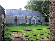
Farmhouse at Cornamagh,
Co. Cavan
© Copyright Kieran Campbell
and licensed for reuse under this
Creative Commons Licence.
The transcription for this parish from the National Gazetteer (1868), provided by Colin Hinson.
- Ask for a calculation of the distance from Enniskeen Parish to another place.
- Who did Mr William RAYBOURNE marry at Enniskeen in 1757? For the answer look here, you won't be disappointed?!
The townland of Enniskeen and the town of KINGSCOURT are both in the parish of Enniskeen.
You can see maps centred on OSI grid reference N7587397800 (Lat/Lon: 53.924116, -6.845827), Enniskeen Parish which are provided by:
- OpenStreetMap
- Google Maps
- Bing (was Multimap)
- Copy
Enniskeen Parishand paste it along with the county name into the search box at Ordnance Survey Ireland. - GeoHack (Links to on-line maps and location specific services.)
- All places within the same township/parish shown on an Openstreetmap map.
- Nearby townships/parishes shown on an Openstreetmap map.
- Nearby places shown on an Openstreetmap map.
- 1630 Muster Roll : Barony of Clankee